  |
||
|
||
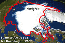
Glub … Glub … GlubAdios Louisiana, Florida and low-lying Chesapeake CountryA guy I know lives along Weems Creek. He can no longer get his boat up to his dock except during high tide because the sediment has been steadily filling in the creek. He’s angry and wants to know, When is someone going to dredge this cove so I can get in and out with my boat like I used to? This is a constant refrain around these parts, and the dredge line snakes way around the proverbial corner. The good news is that dredging is soon going to become a thing of the past. A recent report from the Environmental Defense Council ominously concludes, “In the next 100 years it is predicted that a combination of subsidence and global warming will cause this area to experience a relative sea-level rise of from two to three feet. Impacts from this accelerated sea-level rise are expected to include greater damage from wave action on the Eastern Shore of the Bay, intrusion of saline waters into freshwater marshes and an inundation of wetlands. Some islands in the Bay, including historic Poplar Island, could become completely submerged.” Some folks might wonder who cares about Poplar Island, or any of those other forgotten islands where people cling to the past. Fair enough. How about Annapolis? Big chunks of Eastport will be underwater, along with City Dock. The flooding will not be limited to our historic state capital. Much of Deale and Shady Side will vanish under the waves. Ocean City, Assateague and Chincoteague islands will be sinking into oblivion. With 93,600 miles of coastline, the United States has 15,000 square miles of coastal wetlands and 2,500 miles of barrier islands. All gone by the next century. Children born in the year 2007 will spend their adult life looking down the barrel of their booby-trapped inheritance as the relics of today’s beachfront world are relentlessly swallowed by the sea. I’m Melting!There’s a scene at the end of the Wizard of Oz where the Wicked Witch screams, “I’m melting!” That’s a good one to remember because last year was the warmest on record after a record-setting decade of heat and disaster around the planet. Even more alarming, the Arctic polar ice cap is warming twice as fast as the rest of the earth. The Ward Hunt Ice Shelf is the largest block of ice in the Arctic. In the last two years, it has begun to crumble. When it breaks loose, it’s going to be like dropping the world’s biggest ice cube into the Arctic Ocean. The water in the planetary glass will rise accordingly. That’s why it matters when you hear that the poles are melting. If just Greenland were to melt, the oceans would rise 20 feet. Villages along the Alaskan coast are already experiencing this inexorable rise in sea level. They are the climate canaries of the planet. As these native people abandon their homes and move to higher ground, they are lighting the way toward our dim and terrible future. Like a perpetual motion machine, the melting ice caps accelerate global warming as more of the sun’s heat is absorbed by the planet, further speeding the warming. As the cold water warms, it gets less dense and expands; sea level rises even more, and it’s adios for most of Louisiana, Florida, and the low-lying areas of the Chesapeake Bay. What If?More than half the people in the Mid-Atlantic region live near the coast. Many of us got a bitter taste of what this global warming thing is all about a few years back when Hurricane Isabel hit us with a nine-foot storm surge. Many people still haven’t picked up the pieces of their shattered lives, and disaster relief is in short supply. The writing is on the wall. Allstate Insurance Co. just announced it would no longer insure folks building new homes next to Chesapeake Bay. Waterfront is fast becoming the dead zone. There’s a spooky exhibit at the Museum of Natural History that what ifs a cataclysmic climate change for Washington. Imagine … “If sea level rises one foot, a major storm surge would push the Potomac River over its banks, flooding the park along the river and the Reflecting Pool. The Jefferson Memorial would become an island. If it rises two feet, a major storm surge would nearly encircle the Washington Monument and completely surround the Internal Revenue Service, the National Museum of Natural History and the National Gallery of Art. Muddy waters would even reach the grounds of the U.S. Capitol.” Okay, that last one and the IRS might not be such a bad thing. But all the rest? |
||
|
|
||
|
© COPYRIGHT 2004 by New Bay Enterprises, Inc. All rights reserved. |