On the Road Again
With Maryland’s latest highway map
by Margaret Tearman, Bay Weekly Staff Writer
All you need is the plan, the road map and the courage to press on to your destination.
–Earl Nightingale
The car is packed, newspaper delivery cancelled, the house is locked and maps are at hand — the familiar beginning to one of America’s favorite pastimes: a road trip.
The Automobile Club of America projects a half-million Marylanders will skip packed planes and trains and instead take to the highway for vacations before 2007 is over. The holiday road-load often swells to over 600,000; the busiest travel weekend, Thanksgiving, is still to come. That’s a lot of people looking for the best way to get to where they’re going.
Today’s road travelers are often equipped with high-tech navigational tools, like in-dash global positioning systems, but many of us can’t imagine a road trip without a traditional road map.
Fall travelers can plan their trip with the State Highway Administration’s newly released 2007-2008 Official Maryland State Highway Map, the newest in a long line of Maryland cartograms.
Mapping Maryland’s History
Two of the earliest known maps of Maryland are John Smith’s 1612 map and Augustine Herrman’s 1670 map. These first maps, used for shipping, were meant to show how Maryland was approached from the ocean. They were drawn with west at the top instead of north. With this orientation, Chesapeake Bay appears as a horizontal body of water.
Early Maryland maps weren’t limited to paper. Between 1810 and 1850, slaves using the Underground Railroad invented map songs to guide travelers north in search of freedom. One of the most popular of these songs was Follow The Drinking Gourd: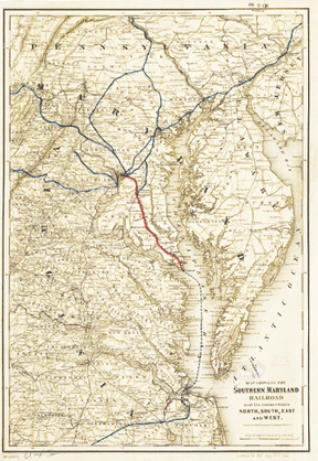
Follow the drinking gourd.
The river ends between two hills,
Follow the drinking gourd,
There’s another tree on the other side,
Follow the drinking gourd.
Where the great big river meets the little river,
Follow the drinking gourd,
The old man is waiting,
for to carry you to freedom
With the Civil War in its infancy, an 1861 pocket map was drawn to show “probable theater of the war” in Maryland. The map noted distances between principal towns and likely battlefields in a state caught in the crossfire.
By the mid-19th century, the industrial revolution was in full swing. Its impact on Maryland is illustrated in an 1881 map of the Southern Maryland Railroad. The map shows a state crisscrossed with land routes — roads and railroads — crucial to transporting goods to a population expanding inland away from seaports.
As a society, we were on the move.
The first Maryland road map was printed in 1910 by the Maryland Geological Survey. By 1915, the state road system comprised 1,304 miles of hard-surfaced roads passable throughout the year and connecting all county seats.
We’ve come a long way in 92 years. Today, the Maryland State Highway Administration maintains approximately 17,000 miles of roads. Those thousands don’t include the many miles of local or county roads, tunnels and bridges not maintained by the state.
It’s Official
In 1934, Maryland Department of Transportation released the first official state highway map. This annual ritual continued until 1941, when the United States entered World War II. As an emergency wartime measure, the state halted new construction of roads; as a result — and to save paper — no new maps were printed over the next four years.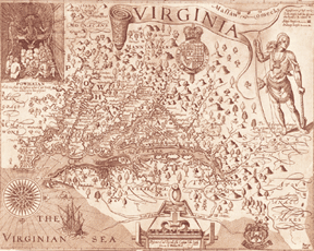
The annual printing resumed in 1946 and continued until 1987, when the highway administration went from a yearly to bi-yearly update cycle. The two-year cycle continues today.
The art of cartography has changed as much as the roads mapped.
In the past, cartographers etched line work and text into a coded film. That film would be sent to a printer, where it would be converted into a negative to be used for color proofing. The negative would be made into a positive that would be slotted into the press.
Today’s maps are drawn on computer using information gathered by surveys, global positioning and satellite imagery. Software replicates the color-proofing process.
But modern mapmaking isn’t all done by computers. It still takes a human behind the wheel to generate the basic information.
“After a road is built, we still go out and drive it,” explains Greg Cooley, manager of the Maryland state highway mapping team. “GPS computers pick up the coordinates and transfer that information in a graphic format to a CAD MicroStation file. We compare the accuracy from what we know to what the satellites tell us. We then make it as accurate as we can.
“The entire state of Maryland is drawn in a MicroStation CAD file in real-world size. In other words, if there was a printer big enough, the completed map would cover the entire state, border to border. We scale it down at the printing stage.”
More than Roads
Over the last 92 years, Maryland’s Official State Highway Map has undergone significant and useful changes.
Back in 1934 the first map was simply a two-colored road map: yellow and black. In 1940, red and brown were added to identify counties. The first full-color map was introduced in 1946. In subsequent years, the color palette grow along with the increasing detail.
In 1967, incorporated towns were shown as mauve or light lavender. Open water was colored dark blue in 1972; in 1974 it was changed to a lighter shade of blue. In 1981, federal reservations went from sand-tone brown to a darker brown.
Sometimes the shade changes were simply aesthetic, but color plays a big role in making maps easy to read. With the vast amount of information on a modern map, colors make the map viewer friendly — for everyone. In fact, color is so important that this year’s mapping team worked with a team of color-blindness specialists.
As the state highway system expanded, so did the map. In 1950, a mileage diagram was added, and the 1952 edition introduced the Chesapeake Bay Bridge. The 1963 map included new interstates 695 and 83; in 1964, interstates 95 and 495 were added as construction was completed. 
The state highway’s map transformation from a simple road map to an aid for tourists began as scenic and historic landmarks were added: The 1958 map noted locations of seven covered bridges, and the ’72 edition introduced a new feature, the Points of Interest insert. Cove Point lighthouse was noted on the map the same year; Sharps Island and Piney Point lighthouses were added in 1985.
The first Maryland Official Highway Map to include a governor’s picture was the 1954 edition, picturing Gov. Theodore R. McKeldin. Gov. Parris N. Glendening changed things around a bit when, in 1995 he was pictured with a group of children. Gov. Robert L. Ehrlich, Jr. was the first governor to be pictured with his family. Gov. Martin O’Malley continues that tradition in this new edition.
The 2007 map brings with it some changes, including an improved mileage chart, different background color, larger text, a map of Baltimore–Washington International Thurgood Marshal Airport’s parking, new symbols for golf courses and lighthouses and, of course, a picture of Gov. Martin O’Malley — with his family.
Maps vs. MapQuest
There are many of us who can’t throw away an outdated, though still perfectly good map and who have well-used — and well-folded — maps with pictures of governors Glendening and Ehrlich stashed in our glove compartment. With so many new-fangled mapping sites on the Internet, will we continue to use paper maps? How many people still prefer the old-fashioned maps with all those complicated accordion folds?
Actually, quite a few.
“We have printed one million of the 2007-2008 maps,” says Cooley. “We have an Internet site so people anywhere in the world can order a Maryland map. Just yesterday we sent maps to Russia, China and Mexico.”
Internet map sites are great for quick trips or to locate a specific destination. Punch in an address, and driving directions to that address are displayed almost instantly. But these sites don’t give you options of things to see and experience along the way.
“A lot of people who order maps use them to plan their trips, and not just a short trip here and there, but a week’s vacation with various stops,” Cooley says. “Our map features popular places to visit. That tourism information is a bonus, and it is a big reason the popularity of our maps has not declined.”
When you take to the highway for an autumn getaway or your Thanksgiving visit over the river and through the woods, don’t forget the maps. Without one, you may drive right by a scenic byway or historic site that would make your trip all the more memorable.
Find free copies of the 2007-2008 Maryland Official Highway Map as well as the Maryland Byways Map and the Maryland Bicycle Map at www.MarylandRoads.com