
|
|
 |
|||||
|
Volume 13, Issue 39 ~ September 29 - October 5, 2005
|
|||||||
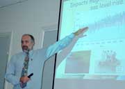
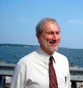
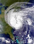 Hurricane School’s In Session Hurricane School’s In SessionScientists are writing the textbook we need to read by Carrie Steele We’re getting to know more than ever before about hurricanes, with lessons we might have preferred not to learn, as they’ve come firsthand, first to Chesapeake Country with Isabel on September 18, 2003, next with Katrina to the Gulf Coast on August 29 of this year, then Rita pounding the western Gulf Coast on September 23. Storms of seasons past are teachers — and their damages still-present mentors — of weather-wisdom. Even as we pick up the pieces, the textbook is being written so we can study ahead for inevitable storms to come. Writing the hurricane manual are scientists, geographers and citizens. In Chesapeake Country, Dr. Donald Boesch and Dr. William Dennison shared lessons with citizens and fellow scientists at the Chesapeake Biological Laboratory as part of a four-panel series sponsored by Maryland Sea Grant, the Maryland Coastal Zone Management Program and Maryland Department of Natural Resources, and continuing in Baltimore, in St. Michaels and in Annapolis — at the Maritime Museum — all locations familiar with Isabel’s power. The duo offered these lessons in Solomons on September 19, two years “to the minute” after Hurricane Isabel’s storm surge was peaking. Now’s the time to study up. Real-life pop quizzes are sure to come. Storm Surges Bill Dennison on Hurricane Isabel What Happened The summer of 2003 was a summer of discontent for a variety of reasons. Howard Ernst published Chesapeake Bay Blues. Tom Horton published Turning the Tide. It was a very wet summer, with high turbidity and low oxygen in Chesapeake Bay. Isabel was the capstone. Her storm surge was particularly manifested up the tributaries and Bay areas like Fells Point and Annapolis. After the storm surge, people were wading and canoeing through downtown Annapolis, Baltimore, Washington, D.C. and Alexandria. There was flooding here in Maryland and down in North Carolina. Boards and decking were lifted from docks and piers. Erosion re-worked coasts and shorelines. There was also a lot of tree damage and power outages. We were somewhat fortunate, in that this hurricane was not a Category 5 as it was at one point on its path toward North Carolina. What saved us was that Isabel ran across the trail of an earlier hurricane that had mixed up Atlantic Ocean waters, reducing their temperature, causing Isabel to power down to a Category 2. Why It Happened The low-lying areas of Chesapeake Bay got flooded, so the Bay grew after the storm passed. This flush was more like taking a deep breath. The Bay gulped in a lot of ocean water. What We Can Learn Natural disasters are really human disasters. Lesson 1. Riprap didn’t work. Hardened coastal barriers didn’t work. We need more soft shoreline approaches. Natural areas were able to withstand the surges. Man-made barriers were not. Lesson 2. We also need community learning about hazards. We focus on the wind. The 150-mph winds of a hurricane are scary, but they don’t kill people. Falling and airborne objects and water kill people. Computerized storm models had a pretty good idea of what was going to happen. But people didn’t get it in time. We lost thousands of cars on the Eastern Shore when people could have easily moved their cars. Lesson 3. We can get an idea of where the surge will occur. Hurricane tracking is pretty good. Isabel went right where they thought it would. What we need is accompanying storm-tide predictions. We need visualization of storm surges. Lesson 4. It’s not just hurricanes that bring surges. Nor’easters can also create the same effects. Donald Boesch on Hurricane Katrina What Happened On entering the Gulf of Mexico, Katrina quickly turned into a Category 5 storm — an even more powerful storm than the legendary Camille and with a higher storm surge. Its strong winds extended over a huge area, driving an immense wall of water into the pocket of coast between Louisiana and Mississippi. As the hurricane’s eye hit land, a storm surge of 20 feet or more smashed into the beachfront communities along the Mississippi coast. Then it proceeded up the Mississippi River Gulf Outlet, washing over the levees built to protect the eastern suburbs of New Orleans. Constructed in the 1960s as a shortcut for ships traveling to New Orleans, the Gulf Outlet had already meant extensive loss of marshes and cypress swamps, further weakening the city of its natural defenses. The water levels in Lake Pontchartrain only rose to about 11 feet, so it now appears that the floodwalls along the drainage canals in the city failed rather than being topped.
Both Isabel and Katrina force us to rethink how we protect people and property from storm surges. We clearly need to do a better job in identifying vulnerable low-lying areas. Lidar surveys from aircraft are helping to more precisely determine elevations in the Chesapeake Bay area. This will guide where we allow buildings to be built and the need for elevation of habitable areas and utilities. With the massive storm surge of Katrina, however, even communities standing well above sea level were inundated. Areas in New Orleans lying below sea level have drawn much attention. These previously swampy areas were not below sea level when they were developed, but the soil has dried and compacted after their wetlands were drained. Many of these below sea level subdivisions did not flood at all, except where floodwalls failed. Stronger levees, floodgates and more reliable pumps will be required to protect these heavily populated areas. However, areas clearly in the line of a massive storm surge from the Gulf might need to be abandoned except for houses elevated on stilts. Rising Sea Level Donald Boesch on Hurricane Isabel What Happened The flooding levels surprised many people, even old timers who remember the unnamed monster storm of 1933. Why It Happened The storm surge during Isabel was very similar to that 1933 storm, which also traveled up the western side of the Bay with winds driving water into the estuary. But with Isabel, flooding levels were about a foot higher. Sea level in the Bay has risen during the past century, mainly due to sinking land, called subsidence. Chesapeake’s land sinks as Earth’s crust rebounds from glaciers that once extended into Pennsylvania. Think of it as a fulcrum. As the crust up in Pennsylvania rises because of the weight that has been removed, land in Chesapeake Country sinks — at a rate of nearly two millimeters per year. Plus, the level of the world’s oceans has also been rising at an average of one to two millimeters each year during the last century. The combination of sinking land and rising ocean led to a nearly one-foot-rise in the Bay’s waterline since 1933. We know this from tide gauges in Baltimore and other places with long-term records. Older residents were able to document this by marks made on the their walls, comparing the height of flooding from Isabel with the 1933 storm. Land subsidence will remain steady in the future, but scientists can say with a high level of confidence that the ocean itself will rise much more rapidly this century because of global warming. Sea level rises because of the expansion of warmer ocean surface waters and also because glaciers are melting, adding water to the oceans. This warming is occurring due to human emissions of carbon dioxide and other greenhouse gases. Even President Bush acknowledged this when he said this summer: “Listen, I recognize the surface of the Earth is warmer, and that an increase in greenhouse gases caused by humans is contributing to the problem.” Scientists cannot precisely say how much the ocean will rise — this depends on how much carbon dioxide we emit — but estimates indicate that, with subsidence, Chesapeake Bay levels will increase two to three feet by the end of the century. Compare this with the one-foot rise during the 20th century. What We Can Learn Recent studies have shown that the number of hurricanes around the world has not been increasing. What has increased is the number of the most powerful Category 4 and 5 hurricanes. We can see this now in flood insurance and building codes for the MacMansions — which replace the modest cottages in waterfront communities — requiring raising habitable spaces, with parking underneath. In other areas increasingly susceptible to storm surges, electrical utilities and fuel tanks should be raised. Lesson III: What History Can Teach Us Bill Dennison on Hurricane Isabel
The unnamed 1933 storm took a similar storm track to Isabel. Isabel’s storm surge data is nearly identical to that hurricane’s, too. In a picture from the 1933 surge, the fence and the road are covered. So this has definitely happened before. There’s also the effect of high tide combining with the effect of storm surge. Wave set-up happens when a series of breaking waves comes up on shore but does not have time to wash back down. This played a role in the damage on Tilghman Island and elsewhere. What We Can Learn These are predictable events. We should be able to plan more effectively than we did. Lesson IV: Vanishing Marshes and Blooming Algae Donald Boesch on Hurricane Isabel What Happened Sea level rise poses a threat to tidal marshes in the Bay region. We’re losing marshes in many areas, and remaining marshes are becoming less dense and lush. Plus, shoreline erosion adds sediment to the Bay, increasing turbidity and negatively affecting underwater grasses. Isabel also caused a large algal bloom, atypical for the fall, that resulted after the storm mixed up the waters of the Bay, bringing nutrients up from the bottom waters. Why it Happened As sea level rises, marsh plants that live in the inter-tidal zone have to increase their elevation; otherwise their roots are permanently flooded and they die. Many Bay marshes lack the supply of sediments needed to build up soil levels high enough to counteract sea level rise. As wetlands’ edges erode with sea level rise, hastened by storms like Isabel, they also migrate inland over uplands. In many areas, this inland retreat is stopped by property owners trying to protect their dry land. Some shoreline erosion happens naturally, but humans make it worse by removing natural vegetative buffers or by installing poorly designed shoreline protection measures. In the case of the algal bloom, the basic problem, of course, is the excessive nutrient pollution that the Bay experiences. What We Can Learn We need to protect marshes from dredging, filling and development and to more actively manage them in the future. Experts are evaluating the placement of clean dredged material from Bay navigation channels onto degrading marshes at the Blackwater National Wildlife Refuge. We need to allow marshes to migrate inland as sea level rises, rather than stopping this encroachment with bulkheads or rip rap. Shoreline protection can adopt living shoreline approaches that still wave action and plant marsh vegetation to grow on shorelines, reducing erosion rates.
|
|||||||
|
|
|||||||
|
© COPYRIGHT 2004 by New Bay Enterprises, Inc. All rights reserved. |
 About the Author