Taking the High Way
100 years of Maryland state roads
by Margaret Tearman
Look through any window, yeah? Any time of day. See the drivers on the roads? Button down their heavy loads? Where do they go, moving on their way? Driving down the highways and the byways.
–The Hollies: “Long Dark Road”
When we hop into our cars and head out to school, work or play, we might think about the cost of fuel or how the car is running. But who thinks of the road — unless it is blocked by snow or traffic, or closed for repairs? But the roads we take for granted have been more than three centuries in the making.
And a century in the paving, which corresponds with the Maryland State Highway Administration’s centennial.
Making Tracks
In 17th century Maryland, roads were few and poor, little more than narrow horse trails. Farmers pushed for Maryland’s first road law, to help them get their goods to market. So in 1666, Maryland required “counties to create roads passable by horse or foot.” Because most commodities in the region were tobacco related, one of the first priorities was to construct rolling roads to roll tobacco hogsheads from plantation to port.
We’re the beneficiaries of 350 years of road design and construction.
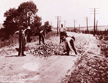
If you were traveling Maryland roads 300 years ago, your trips would test your endurance. In 1708, a handful of dirt roads connected farms to towns and towns to ports. More often than not, these dirt roads were made impassable by mud — if they weren’t washed away.
A hundred years, later, you’d travel more easily. By 1808, private roads were flourishing. Constructed across private property, these roads might be surfaced with rocks, crushed stone, sand, gravel, wooden planks and oyster shells. Gates, or a pike, blocked free access to these roads, and travelers had to pay a fee to proceed. Once the fee was paid, the pike was turned. Thus private roads became known as turnpikes. Road owners could, and did gouge motorists. Some of their roads were well maintained, others not at all.
Toll roads continued as a main route of travel until the end of the century, when railroads rose to dominance, running many of the private roads out of business. But the railroads limited destinations, and not everyone wanted to go where the rail went. Marylanders demanded an alternative.
Paving the Way
By 1908, Maryland boasted 14,481 miles of roads: 13,118 miles were dirt, 890 were stone, 225 were gravel and 250 were oyster shells.
Oyster shells were a native resource. On the Eastern Shore, the only material locally available for road surfaces was the oyster shell. In 1898, the Maryland Geological Survey on status of state’s highways reported that “250 miles of oyster shell road traversed the Shore” with the longest a single stretch reaching from Queen Anne to Crisfield. Arthur Newhall Johnson, the survey’s writer, figured the roads consumed 58,000 bushels of shell per mile. The 250 miles of Eastern Shore roads alone represented almost 141⁄2 million bushels of oysters.
Marylanders were driving automobiles, and for their autos they wanted public — and passable — roads. Exactly a century ago, the State Roads Commission was formed, with a daunting task: build a statewide highway system in seven years and “get farmers out of the mud.” The agency’s specific seven-year plan was to connect all of Maryland’s county seats with paved roads.
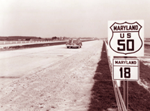
In 1915, Maryland’s first paved state road was completed. Today we know it as U.S. Route 1. But in 1915, that uniquely long stretch of paved highway was a destination in itself.
Until 1922, road building was mostly of grading and paving earlier roadways. The first road actually built on a new location since colonial days was Crain Highway: U.S. 301. The funding for the road was appropriated in 1922, with a groundbreaking ceremony later that year in Upper Marlboro. When U.S. 301 was completed five years later, it was the first direct route connecting the Baltimore region with Southern Maryland. It ran approximately 32 miles from Mattawoman in Charles County to Benfield in Anne Arundel County. It also boasted the first automatic traffic light in the state, at the intersection of U.S. 301 and Old Annapolis Boulevard: Maryland Route 648.
In a century, the State Roads Commission has come a long way. Now named the the Maryland State Highway Administration, it oversees 17,000 miles of paved roads. If the road you are driving on is numbered — like routes 301, 2 and 4 — it is a state road.
Who Knew?
• Early roads were created by digging two parallel ditches and throwing the dirt into the area between the two tracks. This primitive road became known as the High Way.
• In 1922, the first state tax on gasoline was enacted to raise revenue to build and maintain roads.
• Opened in 1940, the Susquehanna Bridge is the oldest toll facility operating in Maryland.
• President John F. Kennedy attended the ribbon cutting at the opening of the Northeast Expressway, or I-95, in Maryland on November 14, 1963. It was the only time a president was on hand to open an interstate highway, and it was his last public appearance in Maryland.
|
Tomorrow’s Road
Roads of the 21st century may be smarter than their drivers, with modern technology playing a big role in highway safety.
“We have ARAN, an automated road analyzer guided by GPS, that uses laser beams and computers to identify rutting, cracking or potential pot holes,” says Charlie Gischlar, Highway Administration spokesman. “We know from these levels when salt needs to be reapplied. Comes in very handy in winter.”
So the administration is using its centennial to preach road safety.
“The biggest thing is that we want to tell folks to do is to live to be 100,” says Gischlar. “We want drivers to be safe behind the wheel. Don’t drive impaired, drive at safe speeds and pay attention to the drivers sharing the road.
“If you do get in an accident road crews are able to respond and clear a scene in approximately 20 minutes,” Gischlar says.
Twenty-five years ago, he says, “it could take as long as an hour from the time we received the call of a crash or disabled vehicle to the time it was cleared.”
Down the road, future highways aim to be user friendly. The Highway Administration is developing technology using roadside sensors and cell phones to gauge speed and traffic.
What does it mean for you?
“Ultimately,’ Gischlar says, the technology will allow motorists to make travel choices through advanced knowledge of routing information and traffic conditions both before the road trip and during it.”
Now if only they could do something about the price of gas …
|