|
 |
|||||||
|
Set Your Compass for an Old Ferry Crossing Crab Creek on the South River38 degrees 57.2 minutes N
|

 Gunk- Holin’ by Alice Snively
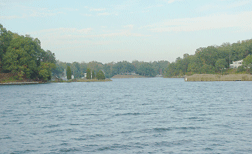 |
On the South River, Crab Creek is a lovely anchorage: It’s narrow, protected and deep enough for sailboats. |
Which Way Is North? Part 2
In my last column (No. 31: July 31), we reviewed the magnetic compass and how to read it. Now let’s examine potential problems of compass behavior, solutions and maintenance.
The accuracy of a compass can be affected by items on your boat. Metal objects and electrical currents can muck up your reading. If you suspect your compass isn’t right, you may need a deviation card. Most navigation books have instructions for creating your own. Sometimes, using shielded cabling for electrical/electronic equipment will solve interference problems
On our boat we have three compasses: one at the binnacle in the cockpit; one mounted at the navigation station inside; and a hand-held sighting compass. They are built to be sturdy, but they can develop problems or be damaged and, as with anything on a boat, it’s wise to have a backup. Keep your cockpit compass covered when not in use, and clean the dome with non-abrasive cleaners only.
If you have the newer fluxgate or other electronic compasses, they must be calibrated. I strongly suggest you read up on the subject and check them or have them checked regularly to assure they’re operating properly. If you’re unsure about your compass accuracy and want expert help, seek a professional compass adjuster.
If you purchased a boat from say, Taiwan, or from the southern hemisphere, make sure your compass has been recalibrated for this area of the northern hemisphere, to compensate for natural anomalies.
On to Crab Creek
Locate South River on your chart, just south of Annapolis. The Thomas Point Lighthouse is a major landmark east of the river’s mouth. As you move west, you will pass the Red Nun 2. Keep it and the Red 4 just beyond to your starboard. Proceed upriver, noting the Green 5 to port and Red 6 to starboard. Continue on between Red 8 and Green 9, and note that the navigable channel is narrower through this section. Move upriver past the Red 10, which will be to starboard, and Green 11, off your port. Pass the Red 12 and look ahead for the Red 14, which marks Ferry Point.
There is no marker at the entrance of Crab Creek; it is the first waterway to starboard past Ferry Point. Stay to starboard as you enter, keeping the stray piling well to port. Once inside, you can anchor in a small cove to port. But the better places to drop the hook are farther upstream. While the channel narrows briefly, there is plenty of water. Run close to the sandy spit at least 75 feet off the beach and you can pass safely. The depth holds to 10 to 12 feet until within about a half-mile from the headwaters, where the creek shoals to about five feet.
Crab Creek is a lovely anchorage. Because it’s both farther upstream from more popular gunk holes and isn’t marked, you may find it uncrowded.
See previous Gunk Holin'