 |
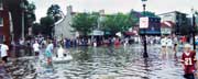
| Isabel’s storm surge flooded Annapolis City Dock, opposite, |
When Will the Bay Flood Again?
Understanding the ups and downs of the Chesapeake
You may have to do some head scratching to understand — but the knowledge you gain might be your safest haven.
by Kat Bennett
Katrina’s storm surge and flooding has killed still uncounted numbers of people in their homes in Mississippi, Louisiana and Alabama. People died in areas considered safe by residents until the storm suddenly turned. Yet all of the flooded areas were under hurricane watch. Not just any hurricane, but a Category 5 hurricane, threatening storm surges of 20 feet or more.
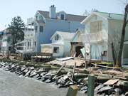 |
| Pummeled Bayfront homes in North Beach, above. |
Here in Chesapeake Country, Hurricane Isabel took many of us by surprise on September 18, 2003, when flood waters surged through the Bay. Since the storm track lay south of the Bay, many people believed that the danger was minimal. Others concerned only about high tide stood vigil until that time, then went home. Less than an hour later, an eight-foot storm surge swept into marinas, houses and waterfront businesses.
Why were so many unprepared?
Perhaps we don’t understand the potential impact of these storms to our homes and businesses. Perhaps it’s our psychology. We don’t like to leave our nests, the places where we feel most comfortable. If everyone gets excited about the devastation and danger of a storm and nothing much happens, when the next storm comes no one wants to leave.
But the weather service is not just crying wolf. The monster is real.
Could it happen to us again? Could we be visited by another Isabel, even a Katrina?
That answer is as complex as the Chesapeake itself. When the water is high in one part of the Bay, it may be low in another. Wind, rain, tides, waves, bottom sediments, storm surge and the shape of the Bay all influence water levels. Sometimes these forces are moderators that protect us; sometimes not.
Read on; you may have to do some head scratching to understand how these different forces work singly and together. But the knowledge you gain might be your safest haven. The Red Cross, which as you read this is working to relieve the disaster spread by Katrina, advises that the first step in protecting your family is to understand how disasters can occur.
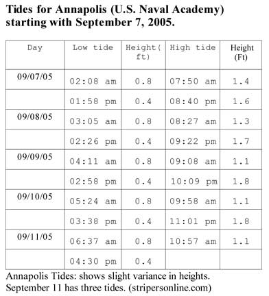
We begin with the heartbeat of the Chesapeake, the tides. Fishermen study the tides to improve their catch; sailors to maximize their craft. We will study them to learn how to protect our families.
Tides: Heartbeats of the Chesapeake
Watermen know that fish follow the tide to feed as the waters flood mud flats and coastal marshes. Tides are the movement of water pulled toward the moon as the earth turns. There are usually two high and two low tides per tidal cycle, which spans roughly one day. As the water rises, it floods mud flats and fills low marshes until high tide; then it ebbs, or flows, out to sea. The resultant rise and fall is normal tidal movement.
In the Chesapeake, the average difference between high and low tide is about two feet. But this average includes high and low tides where there is almost no difference in tidal levels as well as tides almost four feet apart. Why do tides differ so widely? Tidal height responds to the phases of the moon.
The highest high and lowest low tides, called spring tides, occur during the full moon and the phase when the moon is dark, the new moon. Increasing and decreasing the daily tides by as much as 20 percent, these are not tides of the spring season but of the springing waters. Think of them as you have to spring up — or jump down — to the pier tides.
Quarter moons bring neap tides, when the difference between daily low and high tides may be so small that it looks as if there are no tides at all. When the sun and the moon are at right angles, showing us the quarter moon, the gravitational pull on the earth is balanced so that the variation between low and high tides is minimal.
The prime influence on tides is the earth’s position in relation to the moon and the sun. Tides are strongest when the gravitational pull of the moon and sun work together. That pull is exerted when all three planets lie along a single straight line. This alignment of gravitational pulls is called syzygy.
In addition to syzygy, five additional planetary forces increase and decrease these daily flows. The effects may be a small as an inch. But during a flood, that may be the inch that crosses the threshold of your home.
Daily Tidal Variations — A single day’s high tides may not be the same height. As the earth spins, the side closer to the moon has a higher high tide. When we’re the closer side, our high tides are higher; but over 12 hours, the earth has turned us away from the moon. Now its pull on our tide runs in a direct line through the middle of the earth. So our second high tide is lower.
Apogean/Perigean Tides — In addition to the daily changes from the earth’s rotation and weekly variances from the moon’s phases is a monthly effect caused by the moon’s elliptical orbit. This planetary pull lowers low tides and raises high tides a bit more. As the moon orbits the earth once a month (about every 271&Mac218;2 days) it follows an elliptical orbit. There is a visible difference every month as the moon spins closer to the earth, toward its perigee, and farther away from the earth, toward its apogee.
Proxigean Spring Tides — About once every year and a half, forces coincide to bring proxigean spring tides. That confluence comes when the closest perigee, called the proxigee, falls during the full or new moon. These tides cause a 25 percent change in tidal levels, sufficient to absorb some surges at low tide or cause flooding during high tide.
Tropical/Equatorial Tides — The moon’s elliptical orbit shifts back and forth across the equator, a phenomenon called the declination. When the moon’s orbit is at its farthest points north or south of the equator as the orb reaches its perigee, the effect, called a tropical tide, brings greater variances in tide levels.
Tilt — While the earth rotates, its axis is tilted. When that axis is tilted toward the sun, there is an additional pull that results in an increase in the sun’s gravitational effects. About once every eight years, forces align to bring the highest high tide. For such a tide to rise, the moon must be full and at its proxigee, or point closest to the earth. What’s more, this proxigee must find the moon at the point farthest north of the equator while the earth is tilted toward the sun.
Adding it Up — Understand how these tidal forces work and you can use your knowledge to define mean high water mark, which is the annual average of the higher of each day’s two high tides. The area above mean high water mark is dry most of the time and something of a safe zone.
Having marked the highest tide, you would be able to predict flood levels along the Chesapeake — if there were no winds and no rain. Here in the sailing capital of the world, on a good day there are winds aplenty.
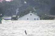 |
photo courtesy of Jeffrey West
Along the Bay and Rockhold Creek in Deale, entire homes were submerged from Isabel. |
Winds Aplenty
“The hurricane is hitting south of the Bay. We don’t have anything to worry about,” said a patron at the Hard Bean Café and Bookstore the afternoon before Isabel hit. What he didn’t know about hurricanes proved him wrong.
Winds blowing up or down the Bay raise or lower water levels. So the direction of a big wind has a lot to do with whether we flood or stay dry.
A 30-knot near-gale wind from the north can cause a drop of almost three feet at Baltimore. Watermen call it blowing the tide out of the Bay. Because the Chesapeake is angled, water isn’t really blown out of the Bay. Instead, it piles up, as much as three feet, along the Eastern Shore coastline near the Chesapeake Bay Bridge Tunnel.
Strong easterly or westerly winds might kick up a lot of chop, but they don’t change water levels noticeably. Winds less than 20 knots are not strong enough to have a significant effect.
But winds coming from the southeast blow water into the Bay and raise water levels in Baltimore and Annapolis. That’s why Hard Bean Café was flooded hours after that coffee-drinker dismissed Isabel as a hurricane passing south of the Bay. Whenever a hurricane passes south of the Chesapeake, we should do a lot more than worry. We should prepare for the worst.
Historically, the Chesapeake has been lucky. Most storms blow up the coast, grazing the Bay with that weaker left side, or miss entirely. If only the left side of the hurricane passes through the Bay, water is forced out, offsetting flooding. In a left-side hurricane, wind strength is also lessened as the storm’s speed of motion subtracts from the wind speed. For example, if a hurricane with winds measured at 100 mph is moving at 20 mph, the effective wind strength on the forward right side is 120 mph and 80 mph on the left.
Even if a hurricane were to make landfall along Maryland’s coast and move through the center of the Bay, the winds would blow westerly until the eye passed, then shift easterly. The result of a center-Bay hurricane would be heavy wave action.
Isabel, however, gave us a taste of what can happen if even a moderate storm takes a turn for the worst. When the right side of a hurricane moves through the Bay, it acts like a giant waterwheel, pumping more and more water up and up. That’s what Isabel did.
Worse, as the hurricane moves, wind speed on the right side and the hurricane speed of motion add together. This powerful punch hit Mississippi during Katrina, blowing away an entire town.
Even storms not predicted to make landfall are ignored at our peril. Offshore storms can cause serious flooding. That’s because winds blowing toward the ocean shorelines create long waves that spread out along the coastline. When one of these waves, whether as part of a hurricane or from a separate storm, moves into the Chesapeake, it adds to the existing water levels. A moderate offshore breeze blowing 11 to 16 knots (12 to 18 miles per hour) for six hours can cause a high tide to rise as much as a foot above the predicted level.
The weather forecast may call for an approaching storm to turn away from land, but even as it turns it could send water levels up several feet.
During an active storm season, a low-level storm making landfall near the Bay can be influenced by a second storm still out at sea.
Adding it Up — To estimate true likely water levels, understanding how winds can raise or lower local tides. Watch for storms passing south where the right side passes the mouth of the Bay. Know that storms moving down from the north can cause water to build up along the coast prior to a hurricane’s arrival. Be cautious about ocean storms that may send wind and water before or after a hurricane, adding more water to flood areas.
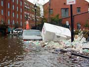 |
photo courtesy Jacquie Greff, www.TonalVision.com
Along Fells Point in Baltimore, Isabel flooded entire streets. |
How a Storm Surges
As a storm approaches land with its driving winds and waves, a great dome of water moves with it: the storm surge. Storm surges rise independently of the tides as if the oceans were still. Their causes are winds and falling barometric pressure.
Barometric pressure is the weight of the air over an area measured in inches or millibars. A one-inch drop in barometric pressure raises the seas by 13.2 inches. Hurricanes are low-pressure systems, so they always bring a storm surge, regardless of the intensifying forces of rain or wind.
The lowest barometric pressure ever recorded on land was produced by a Category 5 hurricane, Camille, at Bay Saint Louis, Mississippi, in 1969. Camille caused a 25-foot storm surge, the highest ever recorded in the United States.
Just last week, Katrina brought the lowest barometric pressure ever recorded in the Gulf of Mexico. Though downgraded to a Category 4 before she made landfall, Katrina caused 24 feet of surge.
Isabel, a Category 2 hurricane, brought surges of six to eight feet near Annapolis and Baltimore, according to the National Hurricane Center. What might we expect on the Chesapeake if we are hit by a stronger storm?
The stronger the hurricane, the higher the surge will be. The slower the hurricane moves, the more impact the surge will have. The wider the hurricane, the greater the area under low barometric pressure and the longer the surge will remain.
As the hurricane eye approaches, water rises more rapidly.
Slow-moving storms (20 knots) traveling northward cause the greatest storm surges in the Annapolis area, while faster storms (40-plus knots) have smaller surge effects. Had Isabel stalled, surge conditions would have been prolonged, falling a little with low tide and rising, perhaps even higher, as the tide came back in.
The surge dome of water moves with the storm, as if the hurricane were a huge magnet centered in the eye drawing the water upward. The surge may begin slowly but increases suddenly as the eye passes over. During Isabel, the surge passed through marinas so rapidly that boats were held down by their lines and sunk. Savvy sailors used two or three sets of lines. In Spa Creek waters rose so quickly that short lines couldn’t be loosed and had to be cut to save the boat.
Adding it Up — Using both the air pressure and the wind speed, The National Weather Service has developed a computer program called Sea, Lake and Overland Surges from Hurricanes, or SLOSH, to calculate storm surges. The SLOSH chart shows barometric pressure and wind speeds associated with different surge heights. If a storm has a high barometric pressure, say 980 millibars, and wind speeds of 90 mph, SLOSH estimates the surge at about five feet over mean tide.
Many scientists use measurements developed for nautical charts to estimate the maximum surge heights. Called the Mean Lower Low Water, these average the two lowest tides each day. However, John Boon of the Virginia Institute of Marine Science suggests using Mean Higher High Water or the average of the two higher tides as the baseline to which the estimated surge heights are added For safety, add an additional five feet.
The Chesapeake Coastal Prediction Center offers real-time water heights, wind speed and tide readings for the entire Chesapeake: http://coastalpredictioncenter.chesapeakebay.net.
Storm Tides Play on Surges
The Chesapeake is most susceptible to high surges when they coincide with high tide. The result is a storm tide with extreme water levels at specific locations during a storm. The storm tide represents the combination of the storm surge and the normal tide caused by the gravitational interactions of moon, sun and earth.
Storm tide peak does not necessarily come at the same time as either the storm surge peak or the astronomical high tide.

Click to View Larger Chart
|
| The Saffir-Simpson scale estimates the damaging power of a storm based on winds alone. The most damaging winds of a hurricane are those along the right-hand semicircle where wind speed within the hurricane and speed of the hurricane itself (speed of motion) add together. |
A 15-foot surge added to a normal two-foot tide results in a storm tide of 17 feet. With Isabel, high tide at Annapolis harbor occurred at about 1am. The storm surge had already begun, but it did not peak until about 2am. A few hours earlier in North Beach, the Bay’s waters surged to eight feet above normal topped by one-foot waves. Many people remained in their homes and had to be evacuated, as floodwaters reached their peak early Friday morning.
Wave Action at Work
The rising mound of storm surge water may be topped with battering waves. Aided by the hammering effect of breaking waves, the storm surge acts like a giant bulldozer sweeping everything in its path. Forecasts of wave heights do not take into account the related forces of wind direction and tidal currents. As many sailors know, waves are higher when winds are blowing against the tidal flow.
Waves can be driven so hard by the wind that they create a general landward-flowing surface current that moves faster than the surplus water can return seaward along the bottom. The result is a flooded coast. In North Beach, Isabel destroyed the boardwalk. Then the waves turned the timbers into battering rams crashing into beachfront homes.
Add Rain and Runoff to the Mix
The Bay area was lucky in one way two years ago. Most of Isabel’s rainfall fell over the ocean and not on land, resulting in lighter than anticipated accumulations. That’s not usually the case with hurricanes, which bring huge amounts of rain, dumping dozens of inches per day, and much of it inland. The slower a storm moves, the more rain it drops.
Had Isabel rained inland, river-borne floods would have added to the Chesapeake Bay area’s woes. When Isabel hit two years ago this month, tributaries already contained large amounts of water from rain and runoff, to which the storm surge added. The saturated ground was unable to absorb much of the surge. Isabel’s low rainfall saved us from greater flooding fed by runoff or river surges.
Yes, rivers add their own burden to hurricane flooding. With heavy inland rainfall, water levels rise in rivers and tributaries to create a crest of water that travels downstream. In the upstream portions of a river, the flood crest passes quickly. Farther downstream the greater volume of water causes slower passage of the flood crest, resulting in longer floods. When rainwater moving downstream meets a storm surge moving inland, flooding is even greater.
Development adds to the danger of rain-driven flooding. The impermeable surfaces we’ve added around the Bay mean more runoff, adding an extra burden of water. In Mississippi as well as here along the Chesapeake, coastal marshes and mud flats have been replaced by waterfront residences. Without areas to absorb the rainfall, flood levels will continue to rise.
Adding It Up — Minimize runoff by planting ground cover on the slopes, building terraces to increase soil infiltration and prevent erosion and building small check dams or retaining ponds to reduce the flow of water. Your efforts help everyone, and the more people working to reduce runoff, the greater the effect.
Piling up at the Headwaters
“I heard that the storm surge would occur around 2am. At 2, the water was about the highest it normally gets during storm conditions so I went to bed,” recalls Lou Schenker, who lives on the Little Magothy, of Isabel. “Around 5am I awoke and checked again. The water had risen along the side of the house all the way to the front yard. There was over a foot of water in the basement, and the water height at the dock was almost to the top of my chest. There was evidence that the levels had already abated about four to six inches, which means that the surge hit Cape St. Claire about 4am. Why?”
The curved shape of the Chesapeake — which is a flooded river system indented by a meteor crater — contributes its own drama to water levels. The Chesapeake is angled, narrowing like a funnel at the north end, where it is fed by major rivers.
As a storm surge moves through narrow channels and approaches land, the water builds height. The physics is similar to that of tidal waves and tsunamis. At river headwaters, the storm surge reaches a dead end and the surging waters pile up, flooding houses high along the banks.
Not just the low-lying coastal areas are in danger of flooding. Residents along steep river banks and along the many headwaters need to keep watch. If a Category 2 hurricane can send water lapping at basement steps on high tributary banks, a Category 5 might submerge the house.
Adding It Up — If you live close to the headwaters of a Chesapeake river, add two to three feet to surge estimates.
Geological Forces Are Still at Work
Our limited perspective hides from us the fact that geological forces continuously shape the Bay. Global warming has been raising water levels more than three millimeters a year on average, according to the National Oceanic and Atmospheric Administration. The land is also sinking, lowering about one millimeter per year because of a natural process called subsidence.
Close to home, there’s more going on underground. Studies by NOAA in 1997 show that the Aquia Aquifer in Southern Maryland is dropping. As the aquifer empties, the ground compacts. Steady development and constant construction results in more and more wells, which further drain the aquifer.
“The combination makes the Chesapeake have a higher rate of sea-level rise than many other places,” explained Jeffrey Halka, chief of coastal and estuarine geology for the Maryland Geological Survey.
Here’s how subsidence and global warming affect us. The unnamed hurricane of 1933 produced a storm surge that was greater than Isabel’s by slightly more than a foot. Yet high water marks left by Hurricane Isabel may have exceeded similar marks from that August 1933 storm. The equalizer was the difference in monthly mean water level for August 1933 and September 2003. In the 70 years between these two storms, the Chesapeake had risen 1.35 feet. Tide gauges show that this is nearly twice the global average.
Worse, We Live in an Active Hurricane Cycle
Katrina proved the clairvoyance of the August update from the scientists at NOAA’s Climate Prediction Center, which warned of an upcoming “extremely active season.” A total of 18 to 21 tropical storms are predicted for 2005, with nine to 11 becoming hurricanes and five to seven of these major hurricanes. These levels are comparable to the hurricane seasons, August through November, of 2003 and 2004.
“There are 20- to 25-year cycles,” said Scott Kiser, tropical cyclone project manager for the National Weather Service. “We are in a period of high activity that started in 1995 and is estimated to last another 10 to 15 years.”
With the aftermath of Hurricane Katrina spread out before us, nature is showing us what she can do — with and without our help.
Subsidence and global warning are raising day-to-day water levels. Storms are becoming more intense and more frequent. Natural buffer areas are disappearing and runoff increasing. More and more coastal land is being developed as residential and business property.
With very little rain and Category 2 strength, two years ago this month Isabel destroyed more than 3,300 homes in Baltimore County. In Anne Arundel County, 72 homes collapsed, with 600 others uninhabitable. In Calvert County houses were destroyed during the storm, all in North Beach, where so far 23 more have had to be demolished. On the Eastern Shore people as far as 150 miles inland had to be rescued by boat. Magnify that damage to the level of a Category 5 with heavy rains, and consider your own home.
Adding it All Together
To understand how a storm will affect your neighborhood and home, you need to know the answers to these questions:
- What is the category of the hurricane? Know the wind strength, speed of motion and barometric pressure to understand how much danger is possible.
- Will the storm come ashore head-on or graze the coastline? Follow the movement of the storm as it approaches land and estimate offshore flooding potential.
- Will the right side, left side or center of the hurricane strike your area? Keep track of every hurricane that is active in the Atlantic. Don’t allow yourself to be surprised.
- How saturated is the available ground? Check the water levels and saturation levels before a storm hits to see how existing conditions might moderate or intensify the storm.
Find your answers at the National Hurricane Center: www.nhc.noaa.gov. Tracking maps, predictions and estimates are updated regularly during the life of every major storm.
- What is the longitude and latitude of your home?
To track a storm’s approach and estimate the danger to your home, calculate the storm’s distance at a Caribbean tracking site: www.stormcarib.com/distance.htm. Prepare sand bags for low-level flooding.
Find your local latitude and longitude by entering your local river or town at www.nationalatlas.gov/natlas/Natlasstart.asp. Or use your GPS.
- What is your elevation?
See the National Geographic Service for maps that show elevations in 10-meter levels: http://edc.usgs.gov/geodata.
- What are the tides and likely actual water heights?
Use these to determine the potential storm surge. Find either the predicted tide or the actual water level at NOAA (www.coops.nos.noaa.gov/tides05 ) or the Maryland Department of Natural Resources: www.dnr.state.md.us/fisheries/access/tide_finder.html.
- Are you are located on headwaters, channels or flood plain?
The Federal Emergency Management Agency, FEMA, shows flood maps at www.fema.gov.
Getting Ready for the Next One
The next time the forecaster calls for a severe tropical storm or hurricane, your best protection is to be prepared.
- Get Current weather information: Check a Citizens Weather Observation Station (www.wxqa.com) to keep abreast of movement of waters along the Bay. Even better, join as a monitor.
- Keep a disaster supply kit on hand. It should include enough food and water for three to seven days, radio, flashlight, batteries, cash, first aid supplies, prescription drugs, clothing, tools and fuel. Plan on one gallon of water per person per day. Food should include ready-to-eat or instant products. Pack in a case that can be carried. Pack this kit whether you live on the water’s edge or inland. Flooding isn’t the only danger. Damage to a home, loss of power or contamination of drinking water may also require you to seek shelter away from your home.
- Know your county’s Disaster Mitigation Plan. Get a copy of Anne Arundel County’s Guide to Emergency Preparedness: www.aacounty.org/OEM/resources. Anne Arundel citizens can also request emergency trainers to give presentations for community, youth or church organizations: Barbara Fay: 410-222-8040. Find Calvert County’s guide to hurricane preparedness under Resident Guide at www.co.cal.md.us/
- Bookmark Maryland’s Disaster Center Page: www.disastercenter.com/maryland/maryland.htm
- Have an evacuation plan ready. Fill your evacuation vehicle with fuel. Make certain everyone in your family has a place to go. Know what you will do with your pets.
- Review storm safety with your family. Most people who are killed during a hurricane die in flood or surge waters, and half of those deaths are vehicle related. If you come upon high waters, follow the National Weather Service slogan: Turn Around, Don’t Drown. Flooded areas also can conceal broken metal and glass.
- Keep a radio with a weather band and listen to it.
—Kat Bennett
|
To Help Katrina Victims
To find reliable organizations accepting donations:
To find your local Red Cross chapter and what you can do:
|
 About the Author About the Author
Freelance journalist and science editor Kathleen Bennett draws on a psychobiology degree for environmental issues and a sociology degree for statistical analysis. |
|